Antique Eldridges Map of Marthas Vineyard, Circa 1913- Framed


This antique Eldridge Map of Marthas Vineyard 1913 is in wonderful preserved condition.
Having been framed it suffers no rips, tears or staining.The glass is intact without breakage.
It measures 38" length x 27" height and has a hanging wire- ready to go on the wall.
The wood frame is a soft sage green which accents the details of the map.
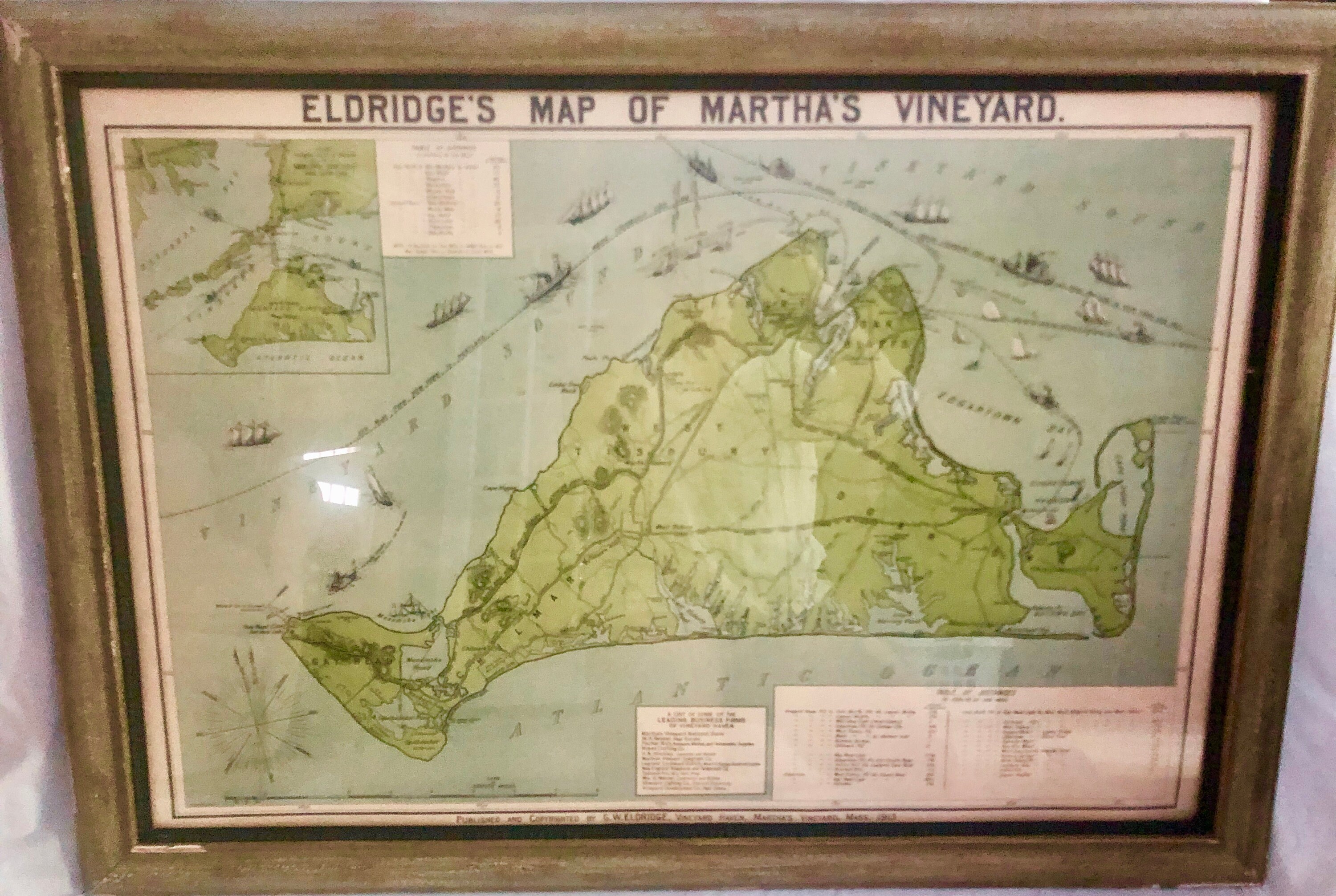
The map was first published in 1892. This is the 1913 second edition, featuring a number of changes and additions
The map provides much detail of the Marthas Vineyards topography, roads and railroads, landmarks, and property ownership.
The visual appeal of the image is greatly enhanced by the bright and attractive coloring, as well as the numerous vignettes of steamships and sailing vessels plying the waters around the island.
It also offers much information of particular value to visitors, such as the routes of the steamship lines serving the island, the locations of steamboat landings and inns, and even promising sites from which to fish for bluefish and striped bass.
Also included is a small inset map showing the location of Martha’s Vineyard relative to the Elizabeth Islands, Cape Cod and Buzzards Bay, as well as tables of on- and off-island distances.
The visual appeal of the image is greatly enhanced by the bright and attractive coloring, as well as the numerous vignettes of steamships and sailing vessels plying the waters around the island.
The map was published by G.W. Eldridge of Chatham, Mass. (1845-1914), the son and heir to the business of George Eldridge (1821-1900).
The senior Eldridge produced his first chart (of the waters around Chatham) in 1851, and the firm bearing his name continued issuing charts until 1932, while the Eldridge Tide and Pilot Book remains in publication to this day.
In contrast to the complex charts issued by the U.S. Coast Survey, Guthorn praises those issued by the Eldridges for their “good design, simplicity, and omission of extraneous shore topography, legible sounding and notes, and the use of compass courses only… Their loyal public; fishermen, coaster, tug masters, and yachtsmen, often continued to use obsolete Eldridge charts until the beginning of World War II.
Shipping from United States
Processing time
1-3 business days
Estimated shipping times
- United States : 2 - 3 business days
I'll do my best to meet these shipping estimates, but can't guarantee them. Actual delivery time will depend on the shipping method you choose.
Customs and import taxes
Buyers are responsible for any customs and import taxes that may apply. I'm not responsible for delays due to customs.
Payment Options
Returns & Exchanges
I gladly accept cancellations
Frequently Asked Questions
Are these new items?
All items in my shop are vintage and antique meaning previously owned, loved and used.
I will disclose any condition issues to the best of my ability in the item description and ask that you review pictures and description prior to purchase.
Please contact me - I'll be happy to clarify and answer any questions.
Do you accept returns?
I do not accept returns or apply refunds
Please review item description and pictures prior to purchase or contact me with any questions
I’ll gladly provide any additional
information
If it is agreed upon between the seller and buyer that an item will be returned,it is the responsibility of the buyer to pay for return shipping. Once the item is received to the seller a refund of the purchase price only will be applied to the buyers account.
I ship quickly -1-3 business days-so I will only except a cancellation within 24 hours of purchase since I will be preparing the item for shipment in order to expedite your purchase
Why are shipping costs so high?
The shipping cost is determined by the postal service which is described below Due to the various sizes and weights of the items in my shop I unfortunately cannot offer free shipping
I utilize the USPS for shipping all packages and have found them to be the most economical and reliable
USPS has discontinued Regional Rate Box prices. This means that this mail class is no longer available
USPS uses Cubic Pricing rates which are determined by package dimensions and distance traveled instead of weight
0 items in your cart